
Plan your perfect day-hike or camping trip and explore the same beautiful north woods trails we enjoyed this week.
For easy planning, each trail is formatted to include a route map, a trail map, and contact information - all on one page. With a quick glance, you are on your way to the great outdoors.
Download the printable PDF to your mobile device for offline viewing and print a backup. Remember, batteries lose charge.


COVID Camping
in Michigan - Week Three
This post contains affiliate links for products we value and believe you will find helpful. See full disclosure here.
AUG 30, 2020
COPPER HARBOR
Back at camp yesterday evening, we had enough light to pack up 90% of our gear for a quick hook-and-go morning. We slept hard and woke up at 8:45 am - central time. Most of the upper peninsula is on eastern time, which put us at 9:45 am. So much for our early start.
Once on the road, we headed for Copper Harbor (Copper Harbor City Map) at the very tip of the Keweenaw Peninsula, the northernmost extent of civilized Michigan (I believe Isle Royale is farther north). Our first stop along the way was at a tiny city park in Bruce Crossings, where highways 41 and 28 cross. I played at the Bruce Crossings’ high school homecoming dance in a band when I was 15(ish) years old. The booking agency, Gary VanZeeland Talent, sent us up to this godforsaken outpost for a total of $150. My cut, after expenses and the manager’s fee, was something like $12. But at 15, I would have paid $12 to be out on-the-road with a band.
I had read that the park at Bruce Crossing's Stannard Township RV Park had a small campground with all the amenities for only $10. The campground was there; it was $10; it did provide electricity, water, and toilets; but it was closed for the season—another casualty of COVID.
Our next stop was Walmart in Houghton. We had thought up many ideas to make our lives even easier on the road, but we needed some hardware to assemble our inventions. While there, we bought another bazillion dollars worth of food that we didn't need. It was fun.
I was very apprehensive as we approached the Fort Wilkins State Park Campgrounds at the very end of the 1,990 mile-long US Highway 41 (which starts in Miami.) The campsites were expensive, and we planned to stay several days. We may even wait out the crush of the Labor Day Weekend. The Keweenaw Peninsula requires a lot of exploration, and we didn't want to miss anything.


The kid at the office told us that there were many campsites available. He circled only three available sites on the map and sent us on our way to look at them. Three is not "many" in my vocabulary, but it wasn't zero. The first two were smaller than a sardine can. The third one, the best one, was just being taken as we pulled up for our look-see. We returned to the office, where the kid sheepishly grinned and apologized for renting out that site. Oh well, but miraculously, the campsite next door to the one we wanted became available. We grabbed site 127 on the West Campground through the Labor Day Weekend (or leave earlier and get a refund if we choose).
Our site, although not very big, was comfortable enough to fit our small rig. We happily set up, hung the washed clothes out to dry to take advantage of the sunny forecast, and took off to explore the local area before ending our day.

SEP 1, 2020
LAC LA BELLE / BETE GRISE
The plan today was to find a trail or two to hike. I had read about the Bear Bluff trail iin a remote area on the southern shore. It is supposed to be a 3-mile loop with some lovely views. In that area is Lac La Belle, a large lake with a navigable channel into Lake Superior. Just above the channel is supposed to be a white sand-dune beach on Lake Superior. These were all eventual sights on our itinerary.
For some reason, it took us forever to get out of the camper. Coffee and breakfast just seemed to go in slow motion. We finally fired up Saturn (our Ford Transit 150 cargo van) around noon. The first 10 miles of Highway 41 snakes under an extraordinary tree-cover of maples with bright red fringes. Colorama must come very early way up here.
About 20 miles down Highway 41, we drove south on Lac La Belle Road towards the town of Lac La Belle. Not much there, except an ideal boat launch to the lake.


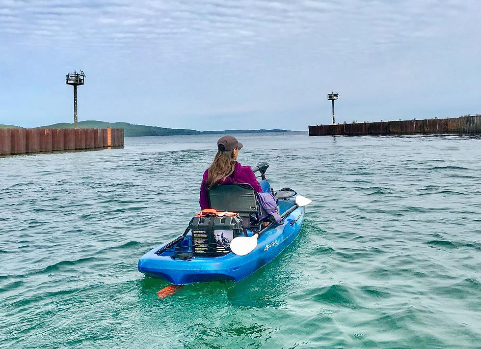
From Lac La Belle on Bete Grise Road to Bete Grise, paralleling the Lac La Belle Lake, took us to a long clean sandy beach ending at the Mendota Lighthouse. A short walk to the Mendota ship canal is a boat launch between the Lac La Belle Lake and Lake Superior. The boat launch is just a sand landing and sucks for boats, but it's a great kayak landing.
The lake map displayed Lac La Belle lake as a long channel with lots of lagoons to explore. Plus, the day was reasonably warm, lots of sunshine, and calm. Even Lake Superior was nearly dead calm. Hmmm, time to switch gears, scrap the hiking plan, and get the electric kayaks out.


Once launched, we bee-lined for Lac La Belle Lake. The lake is mostly undeveloped, with only a strip of cottages along the eastern shore. Strangely enough, the cottages are all very modest. We expected mansions on such an extraordinary water body that has access to the world through Lake Superior's navigable channel. We cruised around the eastern bay before returning to explore the lagoons.
Some of the lagoons spiraled back into the channel, which was fun. One channel turned out to be a mile-long dead-end lagoon. At the end of the lagoon was the Bete Grise village. On the drive, we had searched for the little town of Bete Grise along the Bete Grise Road with no luck. Here it is, hidden along this long channel, well protected from the harsh weather that Lake Superior can regurgitate.


Finally, it was time to enter the big Lake Superior. As we passed through the dredged-out deep channel to Lake Superior, the clear green Superior water boiled as it combined with Lac La Belle Lake's current. Our little kayaks felt fragile, even in the calm waters on a windless day on Lake Superior's vastness.

We arrived back at the boat launch at the same time another couple in regular kayaks landed. We proudly drove off after we packed up, with all of our electric gear, far quicker than the couple with a standard kayak. What an effective team we've become.
We never did find the Bear Bluff Trail, so we drove along the scenic south shore road. To reach the shore, we had to backtrack to Lac La Belle and catch the beaten up rough Gay Lac Labelle Road, which runs between Lac La Belle and the village of Gay.
Like the north scenic road, this road had many inviting look-sees stops at every beautiful view, complete with picnic tables and toilets. At Gay, a rundown and tiny village, we headed back up toward the northern scenic loop on the Mohawk Gay Road, connecting Gay and Mohawk. (Originality abounds in this corner of the world.) These interior towns lack the beauty and tourism dollars that the northern coastal towns enjoy.


From Mohawk, we drove back to the gorgeous coastal town of Eagle River. The Brockway Mountain Drive, which parallels Highway 26 and runs atop a mountain spine overlooking Lake Superior was badly in need of resurfacing and too tree-lined, blocking any lake views for a rough 15 miles.
Suddenly we broke out into a magnificent view, high above the lake. A strategically placed wayside with toilets (they are everywhere on the Keweenaw Peninsula) allowed for superior viewing. For the next 5 miles, waysides, stunning views, and toilets were almost continuous. We oo' ed and ah'ed so much that we forgot the lousy the road condition.
It was another day in Paradise. A cooler paradise than our favorite tropical destinations, but Paradise nonetheless.
SEP 2, 2020
FORT WILKINS
Camping chores sucked up most of the morning. Our biggest choreventure was to drain the grey water tank. Until now, we have been able to drain while hooked up. Most greywater comes from our very short submarine showers. So we barely have much greywater accumulating in the tank.
This time, remaining in the Copper Harbor campsite for 7 days, we will have to drain the greywater without hooking up the Camper (T@B 400) and dragging it to the dump station. I brought along a greywater tote-cart for just such an occasion. The tote-cart is a 15-gallon tank on wheels that hooks up to the van's trailer hitch and pulled to a dump station. The T@B 400's greywater tank is around 20 gallons when the indicator shows 2/3rds full and pretty much fills the greywater tote-cart tank.
Greywater can be foul-smelling, but we use a special Happy Camper powder. It's easy to use and 100% effective - just dissolve the recommended amount in a small bowl and pour down the drain when refilling with potable water. Happy Camper works wonders eliminating odors when transferring greywater out of the camper to the tote-cart.
The dump station was too far to tow-hitch the tote-cart to the van, so Wanda and I hoisted the portable greywater tank inside the van and drove to the dump station. That turned out to be far easier than it sounds. One nasty job was completed, which turned out not to be nasty at all. We don't do black water, which is the most gruesome dump job of all.
The daily clothes washer needed filling, the required floor sweeping, the outside mat required sweeping, and Saturn (our Ford Transit 150 cargo van) needed a little organizing. Oh, life on the road is so tough.

With chores completed, we walked the short trail from camp to the restored Fort Wilkins living history museum, named after the Secretary of War, William Wilkins, serving under President John Tyler (1844 to 1845).
I didn't expect much. It wasn't a fort for very long, maybe a dozen years or so during the 1840s. I figured that the few old buildings forming the large square would take 5 minutes, and then we'd be off finding a hiking trail.

But, the care and detail given to recreate life in this harsh part of the world blew me away. Each building and house had its original purpose wonderfully documented with original furnishings and tons of artifacts laid out like full-scale dollhouses. From the quartermaster's record books to the officers wive's cookware, the displays fully captured the attempt to civilize a rugged and dangerous territory. The housing was cozier than expected.
Boredom during the long winters was relieved with barrels and barrels of whiskey. Those that imbibed too much were locked away in the stark hoosegow. One young man was jailed for general worthlessness.
Fort Wilkins is on Fanny Hooe Lake, a long inland lake that runs parallel to the shore of Lake Superior. Fanny Hooe was the sister-in-law of one of the officers stationed at the Fort. I’m not speculating how they spent the long dark harsh winters but, they did name the lake after the sister-in-law.
All-in-all, we spent well over an hour peeking at this historic moment in time.


We came to the Upper Peninsula to hike, damn it. It was time to hike. We found ourselves driving down a cow path to the trailhead for the Horseshoe Harbor Trail. This trail is the usual tree-rooted, tree-canopied route that we are growing accustomed to hiking on the peninsula - rugged and beautiful.
Just when we were wondering if we were on the right path, we emerged onto a spectacular bay lined with red gravel and sand on one side and large chunks of red conglomerate rock jutting into Lake Superior on the other side. Little islands of rock littered the bay battered by the lake's incessant hammering.


There were a handful of folks on the beach. One young woman was trying to fly a kite high above us masterfully at times, and then, with a mind of its own, the kite would dive straight for the ground in an uncontrolled crash. That was one hardy kite. No matter how many times it smashed into the rocks, she got it back up in the air.
We also saw a drone flying around but couldn't spot the operator. I was surprised how the tiny little mosquito-sounding craft could fly so stably in the fierce wind. I have always wanted a drone to take aerial photos.
Even though the wind was whipping pretty good, the sun warmed the air enough for a group of brave young guys and gals in their 20s to go swimming in the calm crook of the bay. They showed their toughness and bravery, but they were also loudly howling, and it wasn't from pleasure.

Before returning to V-Jer (T@B 400 Camper), we drove back to the Brockway Mountain Drive overlooks. The weather and lighting was better this time around. It is a special place with outstanding views to photograph.


SEP 3, 2020
CALUMET
The morning broke ferocious and mean. The local radio weatherman had forecaste 40 mph sustained wind with 60 mph gusts along with scattered rain. He was dead-on.
The electricity on the whole Peninsula was out for a couple of hours. A poplar tree fell on a campsite that was, fortunately, empty. The rain came down sideways, however, between the dark, angry rain showers were brief periods of bright blue skies.

This weather put us in slow motion. We were going to drive to Houghton-Hancock and putz around. We didn't leave until well past noon. But first a caffeine stop at Jamsen's Fish Market and Bakery in the Harbor. The coffee was not as good as my phoo-phoo pour-over coffee, but it was hot and cozy on a brisk day while on the road.


In the next photo you can see Copper Harbor’s lighthouse in the background. This lighthouse is only accessible by an excursion boat that is shut down for the summer due to COVID.


On the way, we stopped off at the historic downtown Calumet, Michigan. The entire Keweenaw Peninsula's history is steeped in copper mining. A narrow strip running along the whole Peninsula's backbone contained the purist copper deposited in the world. Native Americans extracted the copper for centuries, but I'm not sure what kind of artifacts were made.
It took about 120 years, from the 1840s to the 1960s, to play out the copper. Although several mining companies were burrowing into the copper backbone, two mining giants dominated: the Quincy Mine and Calumet Mine.
The Quincy Mine, located on the bluff overlooking Hancock, got the purest veins. They followed those veins for over a mile deep. Calumet's ore, located farther up the Peninsula, wasn't as pure, but they had a much larger body of ore to feed off.
It was the Calumet Mine that built the city of Calumet and brought on the glory days. Although past its prime, modern Calumet retains remnants of its copper roots. The downtown buildings, many deteriorating, show what once was. I love the red sandstone block buildings. Two well-preserved buildings are uniquely gorgeous, using a combination of irregularly shaped white and black stone blocks with red brick trim - stunning!

We walked the surprisingly large downtown for about an hour. Several tall churches were fine examples of red stone buildings. An old theater has been nicely restored and was back in operation as an art theater, much like the Grand Theater in Wausau, Wisconsin. A few cafes occupied some of the buildings. Sadly, too many grand old structures were boarded up and foregoing maintenance.


Just a few miles from Calumet is the small city of Linden. There is a municipal campground there, so we swung over to check it out. We are fond of municipal campgrounds and this one, although just a bit cramped, is modern and orderly. Each site has electricity and water. The best part is that it is located on the shore of a lake connected to another lake connected to the harbor channel connected to Lake Superior - unlimited boating.
The trail to the Hungarian Falls, a waterfall on the outskirts of Linden, was closed. We didn't look for an alternate route to the falls. Instead, we drove on.
After our tour, I am embarrassed to report we went to Walmart in Houghton for another round of $130 worth of stuff. Each time I go into that money pit, I swear that it should only ding me $20 or $30 for the few items. It just never works that way. I inevitably emerge over $100 poorer.
SEP 4, 2020
- HUNTER'S POINT TRAIL
- ESTIVANT PINES NATURE SANCTUARY
What a spectacular day! We hiked two excellent trails, ate fish tacos, and mingled with 500-year-old Hemlock trees.
The first trail, Hunter’s Point Trail, (or see Alltrails Interactive Map) wraps around a broad protective bay guarding the harbor at Copper Harbor. It is only a 2 1/2 mile round-trip hike, but it features more of the rugged Lake Superior coastline and an assortment of colorful rocks that we can’t stop ourselves from collecting. Dark maroon kidney-bean colored gravel dominated, but many blues and whites intermingled in the mix. The big rock structures fighting off the Lake’s pounding just offshore were a mix of the jagged conglomerate rock, sprouting multi-colored lichen, and smoothed Jacobsville sandstone.


The fish taco stand, rarely open, was alive around 3 pm. We stopped for a takeout fish taco with fries. Once I got it through my head that the fish tacos weren’t Mexican, I liked them. Instead of salsa, they took to pure ketchup much better. (This isn’t Puerto Vallarta, Dorothy.) The fries, our second batch of fries all summer, were typical nondescript fries and wonderful with ketchup - hot, crispy and decadent.
Our next trail was in the Estivant Pines Forest. This sanctuary of nearly a square mile is thick with 300 to 500-year-old Hemlocks. The 2 1/2 mile trail is divided into two loops. We walked both. The Hemlocks, some living before Jamestown was a settlement, are magnificent. Amazingly, these trees never seem to taper. They are as thick in diameter at the top as they are near the root-line. So little of the old-growth pinery survives that it never fails to mesmerize when an old-growth still exists.


SEP 5, 2020
Houghton-Hancock
Today, we finally did the Houghton-Hancock walking tour. But, the morning started at the highly recommended Jampot Bakery. The Bakery had the double benefit of forcing us to drive 22 miles down gorgeous Highway 26 on a glorious sunny morning, indulging in savory carrot cake muffins and feeling its sugar-buzz effect for hours afterward.

Monks run the Jampot Bakery. I don't know much about the monks, their order, or their history, but they are making a "holy" killing at their little business enterprise. I freaked at the $50 fruit cakes and mega-dollar fruit jams, but those enormous muffins were worth the four bucks just for the sugar high and their savoriness as lagniappe.
We also picked up a loaf of dark bread with nuts, chocolate, blueberries, banana, and the kitchen sink. Loaf is probably not the correct descriptive word. A big lump or blob of bread would be more apropos. The taste was heavenly - pun intended. Somehow we managed to get about half the lump-of-bread home after nibbling on it all day. It was even more delicious with a little butter.


Houghton (Houghton RV park) turned out to be a delightful surprise. Unlike so many industrial cities that crumble and rust after their industries go bust, Houghton turned that corner with skill. It was the epitome of good local governance.

Seemingly thousands of historical plaques laid out every 20 feet apart across the city focused the Houghton stories on education and tourism after the mines played out in the 1960s. They did a spectacular job of reclaiming their waterfront, turning a blighted, abandoned warehouse section into a beautiful park, boat marina, modest houses/condos, and walkway/bikeways.
The downtown is vibrant. The historic commercial buildings are restored to their original glory. Even though Houghton's outskirts are marred by the usual big box stores and franchise restaurants, the downtown remains healthy.

The economic engine clearly is the Michigan Technological University. This university isn't some backwater college with a couple of old classroom buildings. Well, it is located in a backwater, way up in nowheresville. Still, it's a sprawling modern campus that would rival any university, especially in beauty, overlooking the water on a bluff. Fraternities and sororities housed in grand mansions line the street for a couple of long blocks in the middle of campus. Houghton's population is 8,000. The university's enrollment is 8,000. I think that puts things in perspective.
Two odd little pieces of trivia hit me: 1-Houghton wasn't a city until 1970. It operated as a village for over 100 years from 1854 to 1970. 2- the first paid hockey team started in Houghton. That team became the seed for the first professional hockey league.
Somehow, I walked right past the Keweenaw Brewery Taproom. I have enjoyed a few of the brewery's Widow Maker Stouts in my day, and I wanted to check the place out. (Much later, I google mapped the brewery location only to discover that we had walked right by it - ARRRGGHH!)

Houghton artists must have had a field day as their paintings are everywhere. These paintings aren't the usual historical scenes. They are remote Keweenaw Peninsula nature scenes of hiking trails, rugged coastlines, and northern lights. (New paintings are up near the National Park Service on the Houghton Waterfront Trail. Artwork by Lori Sleeman.


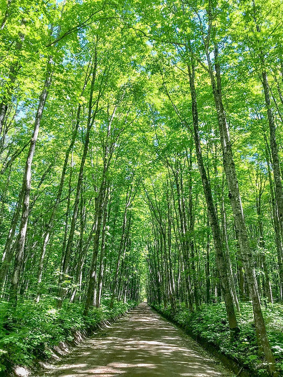
We left Houghton to the west along the waterfront road to a magical out-of-the-way back - back - back road called Covered Road. The name, Covered Road hits dead-nuts on. Like many European roads, the tree trunks were the shoulder of the road. Even though the narrow lane was gravel, it mesmerized as sunlight occasionally flickered through the thick cover of golden leaves and branches.


Now it was Hancock's (Hancock City Map) turn. Hancock, I believe, was established a little before Houghton, which is odd because it is on the north side, or the more remote side, of the waterway that separates the northern Keweenaw landmass from the southern. Technically, the portion of the Keweenaw from Hancock to Copper Harbor is a giant island. The waterway that separates Houghton and Hancock is called Portage Lake and connects to Lake Superior from both the west and the east.


The waterway that separates Houghton and Hancock is called Portage Lake and connects to Lake Superior from both the west and the east. Portage Lake made the two cities valuable ports - protected waters, easy access to the Lake Superior shipping lanes, and two directions. But, copper was discovered in the northern Keweenaw Peninsula, first giving Hancock a leg up on Houghton, at least in the early 1800s.
The double-decked drawbridge connecting Houghton and Hancock is supposedly the largest "hoist" bridge in the world. The bottom deck used to be a railroad. It is now a snowmobile route. In the summer, they keep the middle section up to allow sailboats to go under. For the "big boys" they have to hoist the middle all the way to the top. In the winter, the middle comes down so the snowmobiles can use the bottom deck while cars then use the top deck.

Today, Hancock, lacking the important university and the same forward-thinking government, is half the size of Houghton and half as vibrant. It does have a small college - Finlandia University, a tiny medical college featuring one large classroom building and a handful of smaller structures. Everything about Finlandia is a bit past its prime and could use a little sprucing up. It does, however, hint at a connection with Finland. Apparently, in the 1800s, Finnish people liked the remote, harsh, snowy, cold, desolate, long Michigan winters and emigrated to Hancock. One such immigrant, Big Louie, was an 8' 3" giant. Too bad, it was professional hockey and not basketball that started in Houghton.


Just outside of Hancock is the Quincy Mine ruins. It doesn't look like much, a few rusting pieces of equipment, a couple of buildings scattered here and there, and one very tall tower building. But, it is run as a National Park, so we stopped in.

They are expensive, $40/person, but we missed the day's tour schedule. We were allowed to roam the grounds and poke around. Between a looping 10-minute video in the tall tower and a bunch of info plaques, we could piece together a very interesting picture of the whole operation - and it was quite an operation. The tall building housed the hoist that took the miners deep underground. The main shaft was over a mile deep. The hoist carried 35 miners at a brisk 15 mph ride to the bottom.
I wonder if copper mining was as dangerous as coal mining. I don't think they had methane gas to worry about or coal dust to breathe in black death. But I am sure that cave-ins were a potential danger, and perhaps rock dust is also bad for the lungs. Still, in all of the plaques we read, not one mentioned any accident or health risk.


We love these striped buildings of Jacobsville Sandstones.


SEP 6, 2020
Planning Baraga State Camp Site
We used this day to relax, plan, play some guitar, pay some bills, get ready to move, and generally wind down. By 3 pm, the sky opened up and down-poured for the rest of the day. We usually pack up the evening before leaving but everything was sopping wet.
Instead, as it poured outside, I poured over maps and decided to set up at Baraga State Park, located between the towns of Baraga and L’Anse. Baraga State Park put us in striking distance of the Sturgeon River gorges. Initially, I looked at boondocking at either of two primitive campgrounds a bit closer to the Sturgeon River, but the electrical hookups at Baraga State Park seduced me.
